


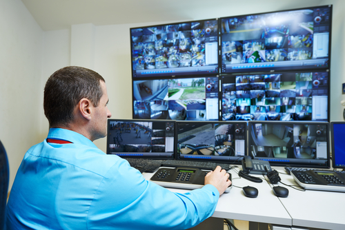
Our airborne technology systems are a fast and affordable way through which government agencies and private companies obtain high quality images from the ground: orthophoto maps for large areas, 3D digital models of surfaces or video capture. These systems can be applied for the use of municipalities, emergency inspectorates, police, coastguard, builders and private companies etc.
With the help of Hirrus unmanned air vehicles systems at the basis of these integrated solutions, we offer our clients access to relevant, accurate and correctly located information in real time. Available only a few years ago to the government agencies in several countries, unmanned air vehicles provide today a much more affordable alternative to the images obtained from satellites, for a faithful reproduction of the surfaces and their details: from hidden fire outbreaks to the height of a building or the signs of pest damage to crops.
The advantages of the integrated technology solutions provided by Teamnet include:
- the use of the most accessible technology for the generation of 3D soil maps and models;
- coverage of large areas in a very short time;
- providing real-time data and detailed reports;
- a flexible marketing system through which the operation activities of unmanned air vehicles and obtaining the permit to fly are conducted by Teamnet team;
- full coverage of workflows through integration with other systems part of Teamnet portfolio or external.

Message of Rob Munday, Chairman of NIAG Study Group – 177, C/O Defence Investment Division
NATO HQ, to Bogdan Padiu, General Manager Teamnet, after the application „UNIFIED VISION 2014” for NATO
“The results obtained during the application „UNIFIED VISION 2014” are due to Teamnet, which you should take pride in.
Despite many challenges and some minor obstacles, the staff overcame all issues with determination and professionalism , to ensure the successful operation. They also demonstrated the capabilities of the HIRRUS platform during the Application. The successful integration of FMV streaming, compatible with NATO STANAG 4609, from HIRRUS to the Application network, has been demonstrated several times during the process and attracted favorable comments from the operational users of images.
I wish you success in the future and we hope that we can work together again in the future, for NATO Applications.”
Municipalities
In public administration, the UAV technology (Unmanned Air Vehicle) can help for a better management of the projects in municipalities, from the planning stage to monitoring the ones in progress.
 The Urban planning departments may increase the accuracy of the urban plans, complement the available data with accurate information regarding the height and the stages of the local constructions and have the ability to make highgly accurate electronic measurements. This becomes possible by consolidating the images obtained using UAVs with some measuring and control tools on an electronic map on several levels. . The electronic map provides an overview of the city: floodplains, green areas, historic buildings etc.
Emergency Situations
With the use of the UAV technology, we can optimize the management of the activities carried out by the county emergency inspectorates, sending real-time data at the scene of an incident.
 The emergency inspectorates can obtain data directly from the scene of the accident, the fastest way possible and with minimum human risks and at minimum costs.
In this respect, we provide the authorities that coordinate the emergency situations with an UAV system for situation, location and information detection and follow up of the consequences.
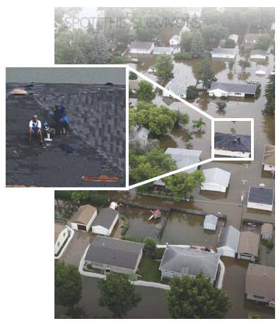
In case of fire, the images captured by the UAV allow the identification of the outbreaks and areas affected. Thus, the inspectorate may send the extinguishing equipment directly to the outbreak, reducing the time of intervention and the costs of the localization equipment for. After fire extinction, the images obtained from the UAV allow for the identification of hidden outbreaks.
In case of earthquakes, an UAV surveillance service allows for the fastest identification of the affected area and the types of damages, in. This is also possible for theareas where the access by car or other means of transport is restricted. After earthquakes, the UAV surveillance service allows for the identification of the disaster consequences and localization of victims.
Border Police and Coastguard
The border police and coastguard can cover large areas of surveillance by using the UAV technology, locate hazards in the shortest time and get real-time information about the importance of the threat, in order to send an appropriate squad directly to the source.
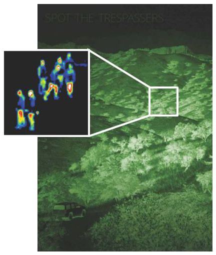 We provide tools for the authorities in charge with guarding the coast and to the border police to detect potential threats on land or water, through the UAV surveillance system.
The border police can use the UAV systems for recognition, in case danger signals are deteced on the land border. The localization of hazards and the data reports received in due time reduce costs and shorten the time of intervention.
Coast Guard can use the UAV systems to locate the unauthorized vessels or those violating the territorial sea navigation system.
Traffic Police
The traffic police can get, in the shortest time, accurate traffic images , from communication hubs or blocked areas and information about the size of bottlenecks and potential victims.
 The police may intervene, thus, in the shortest time, with the squad suitable for the type of situation reported. This is possible due to the use of broad images taken from above and obtained by means of a UAV device and to the transmission of the images captured by the camera in real time.
Agriculture
The UAV technology provides farmers with data they can use in order to quickly respond and maximize crops, by the fast identification of areas affected by pests. The aerial images taken using a UAV system, cover large areas in a short time and accurately capture the lots affected.
 The time used for obtaining data is much shorter than in case of ground monitoring and the affected area is identified quickly. This data faciliates the intervention before the affected area expanded. The data collection and intervention speed will make the difference between a healthy crop and a compromised one.
It is also possible to periodically monitor the state of the vegetation health condition and, thus a more accurate estimation of the quantity of harvest expected is also possible.
Highway Engineers
Road planning companies can increase the accuracy of plannings and can foresee risks and additional costs at an early stage of tendering and works. In a single day, we can get full information about distance, work area route, terrain bumps and area features (flooded, inhabited etc.).
 This is possible through highly accurate, 2D and 3D maps-images models, obtained by UAV technology and due to measurements that can be performed on these images.
We provide the construction companies orthophoto maps and digital surface models and useful information to draw the construction, design and supervision of works.
In the route drawing stage, the orthophotomap indicates the 2D area coordinates and provides the tools necessary to establish the route. The parallel consultation of the hydrographic model allows the identification of floodplains.
For road design and calculation of leveling effort, we provide 3D digital models, in which it is highlighted the height of the land on which the construction is to be performed. The Strippling and elevation levels are highlighted, while the system allows the calculation of the total leveling volume. The elevation of the land on which that road is to be built, helps engineers minimize risks due to the lack of measurements.
For construction monitoring, engineers can perform assessments at fixed time intervals, to update information on the construction stage, the leveling realized and the projected versus completed route.
Physical Security for the Public and Private sectors
With the unmanned aircraft systems, critical infrastructure objectives (energy production facilities, oil etc., power transmission lines, oil products, etc.) can be monitored by video aerial surveillance.
 A major advantage deriving from the use of a UAV system, consists in flying over large areas in a short time. The video sensors capture images by day and night, which are sent in real time to decision makers, thereby contributing to the efficiency of the whole monitoring and intervention process.
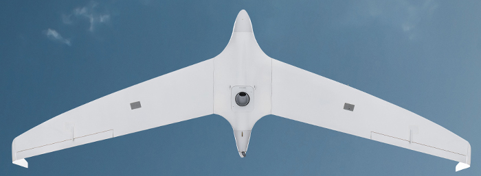
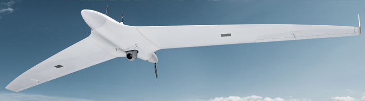
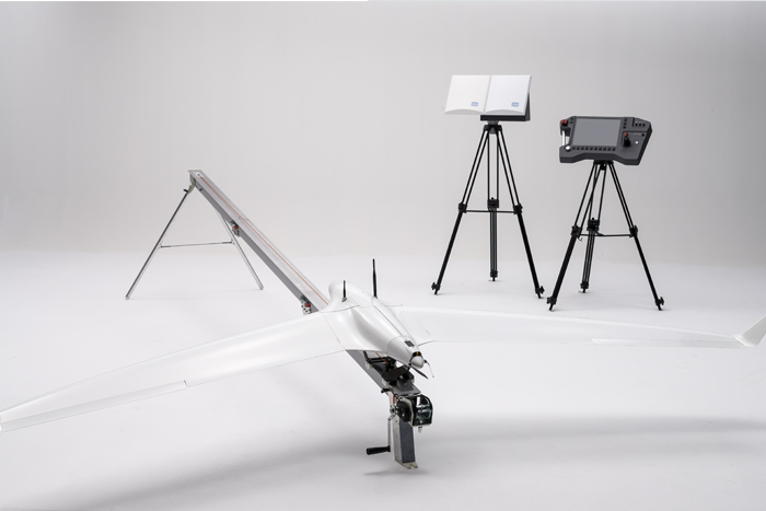
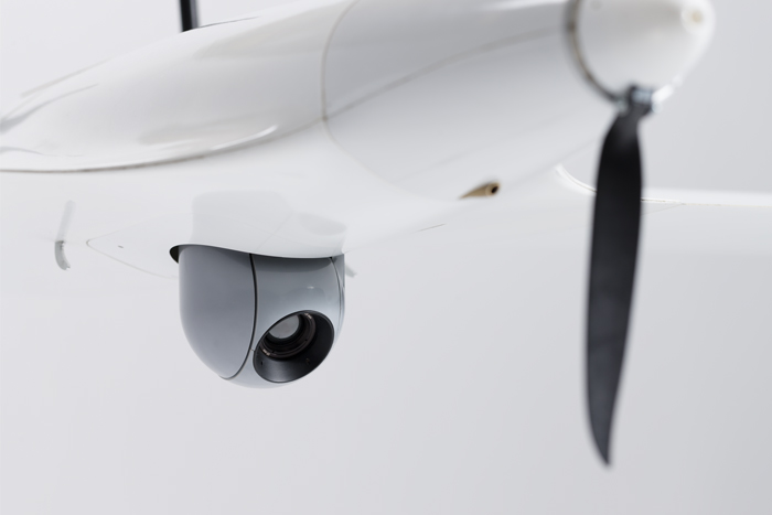
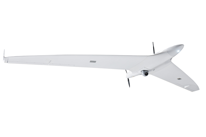
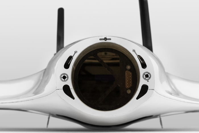
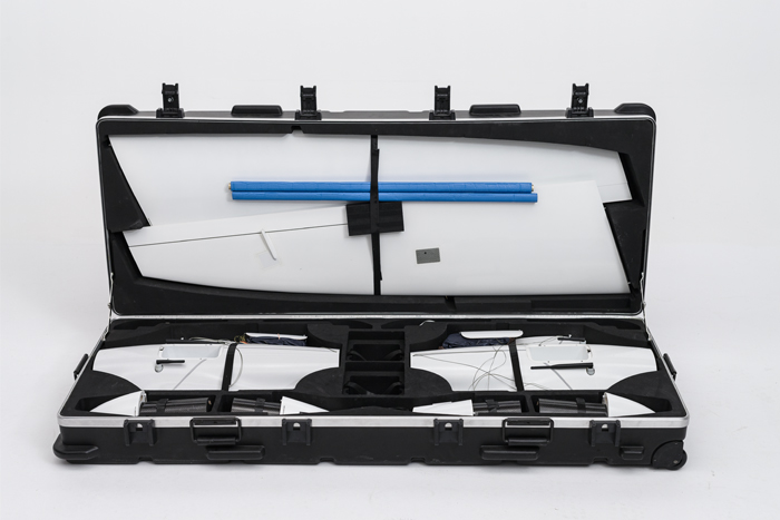
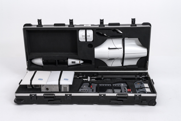
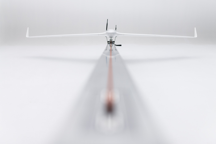
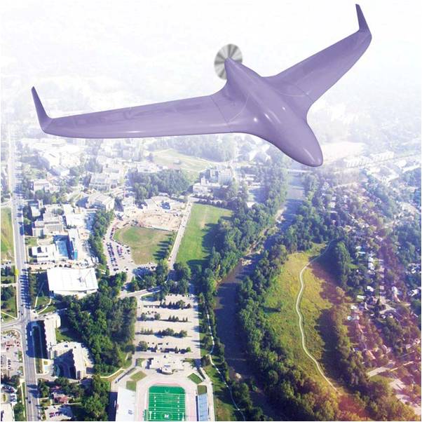
The Hirrus system includes three unmanned air vehicles, a ground control station and emission reception antennas. The aircraft has an autonomy of approximately 3 hours and depending on to the cargo, it can reach speeds of more than 110 km/h. It captures high-resolution ground images, generating images of 5-10 cm/pixels.
Besides the Hirrus system, Teamnet also integrates the technology provided by the systems Șoim 1 and 2. These are target systems for military training operated based on an intuitive software interface of the ground control station, GCS. Due to their robust structure, they can be transport by motor vehicles and the launch can be conducted even in adverse weather conditions. Main features: carbon fiber and composite material components, antennas, automatic navigation, software for mission control and safety parachute.
Research and Development in the field of autonomous systems and robotics
We develop competitive autonomous systems at a regional level, within a comprehensive research and development project, in partnership with academia.
Robonet, the pole of competitiveness in the field of robotics and autonomous systems, is an innovative initiative of research and development in autonomous systems and robotics. Within the project, together with partners in academia and private sectors, we collaborate to implement five projects: research and development of a UAV; research and development of a UMV system; development of a production unit for autonomous systems; project management and promotion of the project at a regional level.
For information about the project, visit http://www.teamnet.ro/en/teamnet-group/research-development/competitiveness-pole/
For information about the project status, visit http://www.robotx.io/
Hirrus system is accessible to a large number of public and private companies due to its commercial policy.
Thus, clients can choose to just get the reports and images, or rent the unmanned air vehicle on a monthly basis or purchase the system, having full control over the equipment.
NATO UV 14 Exercise
Our team accepted the invitation to test the civil UAV systems during the exercise NATO Joint ISR Trial Unified Vision 2014 (UV14), conducted at the Main Aerial Base in Orland, Norway. Together with the most important European companies in the field, we organized a demonstration of the UAV Hirrus system and its capacities of high quality, real-time collection and delivery of key data.
Thus, we have demonstrated the operational capabilities of the mini-UAV Hirrus system whose positioning is as a modern, compact, light and self-sustainable, adaptable system for civilian and military applications. The activity was focused on the demonstration of its capacities to deliver data and intelligence, surveillance and reconnaissance information (ISR) in order to increase the operational efficiency of the forces trained. In UV14 more than 2000 representatives of the NATO states and partner countries such as Australia, Finland and Sweden attended the event.
Preparation
The preparation for participation involved continuous efforts towards obtaining national and international qualification as well as an important number of documents for planning, coordination, certification and accreditation. During this period, there were conducted activities such as field reconnaissance, network connectivity configuration, map uploading, preparation and operation of test flights. The successfully completed activities validated the capacity of the system to meet the highest requirements, especially when it comes to flight safety.
Deployment
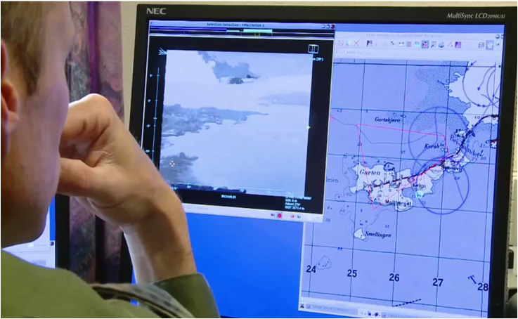
During the exercise deployment, we successfully operated flights based on the scenarios and missions received, according to the objectives established, while providing and broadcasting real-time FMVs (Full Motion Video) on the internet and NATO Unclassified networks. Several system features were tested, such as endurance in unfavourable weather conditions, the use of both sensors in the visible and thermal spectrum, as well as using a ground control station (GSC) as retransducer. All flights performed during the participation and deployment of UV14 were monitored by the Norwegian Liaison Officers in charge with flight safety.
Results
The objectives set during the application were successfully met. Hirrus was among the few systems in the same category providing RT FMV in real time, according to the standard STANAG 4609 and metadata. The NCI Agency and B-Hunter Representatives requested video information from Hirrus in order to use them during the appropriate training activities.

NATO UV 16 Exercise
Two years after the most recent drill of this kind, we were once again invited to participate in the NATO Unified Vision trial that took place in June 14-29. The most important UAV producers from 17 countries were invited to the exercise for a know-how exchange that took place during a practical drill aimed at decision support in the NATO command and control center.
The event brought together over 400 participants who communicated information obtained with the assistance of UAV systems in 10 different locations in order to respond promptly to threats in five complex scenarios of which we mention: convoy protection, hostage rescue and internal terrorist threat.
Hirrus UAV operated in the Ilfov area and was coordinated in real time by the NATO Training Center in Germany. The Hirrus exercise dealt with two types of operations: firstly, following and neutralizing a terrorist leader and secondly, protecting an intervention force convoy. During the drill, the following features were under observation: the capacity of UAV systems to detect and follow moving targets, to search and rescue, to monitor and recognize, and to collect CBRN (Chemical, biological, radiological and nuclear) information. On top of this, Hirrus also demonstrated the ability to deliver data in accordance with the NATO standards. Bogdan Nedelcu coordinated the exercise on behalf of Teamnet in Germany.

Cadaster Exercises
Context
Romania, as well as many other countries worldwide, is updating it’s systematic cadaster at national level. These projects require data gathering, mapping, measuring, publishing data and solving legal requirements, for a correct delimitation of inside and outside town properties. With a stretch deadline and a wide area to cover, the project requires a fast response from cadaster companies.
Challenge
The difficult task of covering over 3000 lots by 2020 falls on cadaster offices. With data mapping and on ground measurements covering an important part of the time allocated for this projects, a work and cost reduction on this activity is needed to help deliver the projects in time and on budget.
Solution
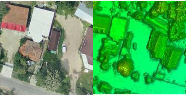
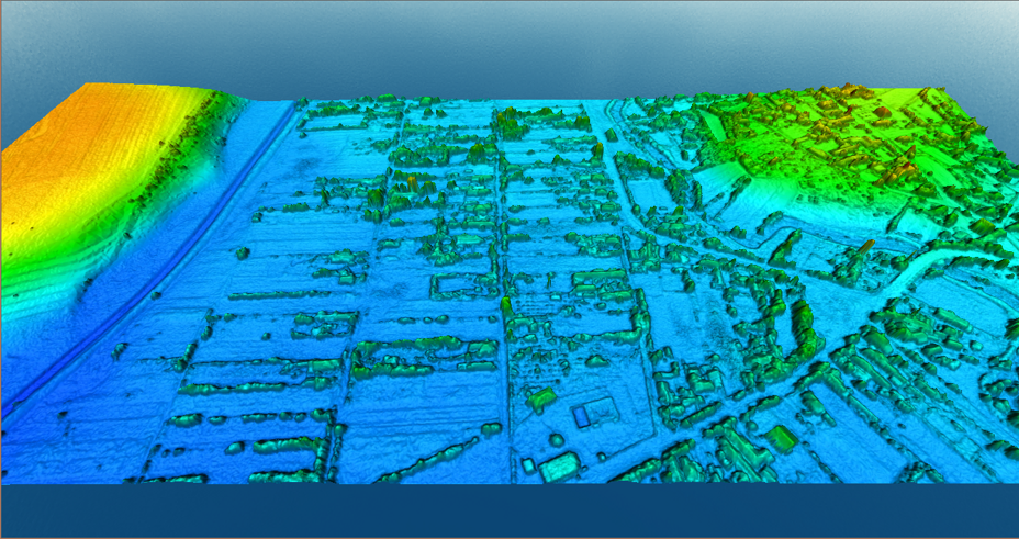
With the help of our airborne unmanned technology, we offer high resolution orthophotomaps of the targeted area, with a resolution of up to 2 cm/pixel. The image obtained provides high accuracy and helps get the preliminary measurements before the on-site visits for validation.
The tool used is HIRRUS, an Enterprise UAV system, which includes three unmanned air vehicles, a ground control station and ground data terminal. The aircraft has an autonomy of up to 3 hours and a cruise speed of around 80 km/h. It captures high-resolution ground images, generating ortophotomaps of 5-10 cm/pixels. It uses a single axe gyro-stabilized 24MP photogrammetry sensor and it can cover 800-1500 ha/hour.
The main deliverables are:
- High-resolution Orto-photomap;
- 3D Points Cloud and Digital Surface Model;
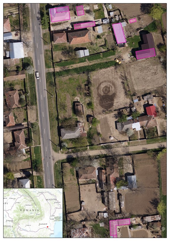
- Vectorization of cadastral parcels, roads and hydrographic network, irrigation channels, electric transformation posts and low voltage lines, Postal Codes etc.
Results obtained:
During one of the flights for a cadaster project in Arad, a city from the Western part of the country, the following results were achived:
- Coverage: 2600 ha
- Checkpoints: 30
- Control points: 100
- Flight time: < 1 day
- Number of aquired and processed pictures: 9900
- Image processing time: 120 h
- Points acquisition time: 2 days
Deliverabiles:
- Ortho-photomap 5 cm resolution
- Digital Surface Model 18 cm resolution
Benefits
The main benefits are:
- Reducing the time to cadaster large territories
- Reducing the number of teams and visits for on-site measurements
- Provides a validation tool
- Increase cost-efficiency in cadaster services
- Increases accuracy for final output
Creates the premises for a digital map easily updatable and a service to be used by all stakeholders.
Hirrus system is accessible to a large number of public and private companies due to its commercial policy.
Thus, clients can choose to just get the reports and images, or rent the unmanned air vehicle on a monthly basis or purchase the system, having full control over the equipment.
Rental services
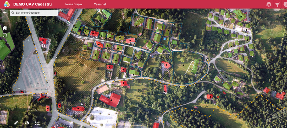
With the use of the geospatial service, we provide government agencies and private organizations direct access to orthophoto maps, at a resolution of 10 cm per pixel and 3D digital models.
This commercial version has the advantage that the maintenance, piloting and flight permits are handled by Teamnet, while the clients obtain the final results: the reports and images.
The surveillance services are another rental option, where clients only pay for the pilot service and the 24/7 surveillance or air availability service in a predefined region, while receiving real time images. Renting the flight services allows clients to change the flight plan according to their needs, at a minimum cost, while renting it for a number of hours per month helps them to keep costs at an optimal level.
Integration Services
We provide the integration of the images from UAVs with other software and hardware systems for complete coverage of workflows specific to each client.
By integrating the unmanned air vehicles with the GIS-type of systems, users get full geospatial information and can perform complex measurements of captured elements (volume, area, distance, etc.).
With the integration of the security and video recording systems, we instantly deliver the information to decision-makers and make it possible for the timely intervention. The data collected using UAVs are in accordance with the 4609NATO standard, which ensures the compatibility with command and control systems and helps having an overview in support of decision-making.
Procurement Services
For long-term surveillance services, we provide government agencies the possibility to purchasing unmanned air vehicles. This commercial policy provides total control of the equipment and has a positive impact on reducing the cost per outcome unit.
In-house management of the equipment is optimal for long-term surveillance. An unmanned air vechicle has an autonomy of 180 minutes, is equipped with video and photo sensors that capture diurnal or nocturnal images of high resolution.